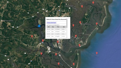
Accurate, simple to use Satellite Map based Georgia tide charts of the all NOAA based Georgia tide stations on a simple to use satellite map. Designed by Georgia fishermen and Professional Georgia Fishing Guides.
NO SPAM ADS, SIMPLE TO USE...100% AD FREE.
Other Features:
Ability to forecast Georgia tides from NOAA by setting date and period for any of the tidal stations for the entire State of Georgia tide tables.
Excellent support for any issues, questions or new features...simply email: [email protected] and well show you how Apple support is meant to be.
Auto-save last location for easy reference to your last tide station the next time you use the tide app.
Included is the ability to zoom and view satellite imagery for fishing ground characteristics to compare with tide movement.
Advanced tide graphs allow for you to judge the level of water movement for optimal fishing between high and low tide in Georgia between tide stations so you can follow the tide flow for the entire day.
Recent Feedback:
"NesTides ability to display tide predictions and actual tidal flow graphs allow me to extend fishing trips by following different tide station tide charts and moving with the tide flow. The satellite view allows me to explore and discover new fishing grounds I never knew existed. Absolutely the best fishing software tool I have ever used. ," said USCG Captain Mike K.
Georgia Tide Chart stations include (partial list see website for full list):
Tybee Light,SAVANNAH RIVER ENTRANCE, FORT PULASKI,Fort Jackson,SAVANNAH,Port Wentworth,Little Back River, Hwy. 17, Back River, S.C.,S.C.L. RR. bridge,Purrysburg Landing, S.C.,Tybee Creek entrance,Beach Hammock,Romerly Marsh Creek,Savannah Sheraton Resort Hotel,Thunderbolt,North entrance,Isle of Hope, Skidaway River,Egg Islands,Vernon View, Burnside River,Coffee Bluff, Forest River,Fort McAllister, Ogeechee River,Highway bridge, Ogeechee River,Florida Passage, Ogeechee River,Florida Passage, Bear River,Cane Patch Creek entrance,Bradley Point, Bradley River,Walburg Creek entrance,Kilkenny Club, Kilkenny Creek,Bear River, (Range A Light),Bear River Entrance,Sunbury, Medway River,Belfast, Belfast River,North Newport River (Daymark 119),North Newport River,South Newport Cut, N. Newport River,Halfmoon, Timmons River,Eagle Neck, South Newport River,Thomas Landing, S. Newport River,South Newport River (Daymark 135),Dallas Bluff, Julienton River,Harris Neck, Barbour Island River,Barbour Island, Barbour Island River,Blackbeard Island,Dog Hammock, Sapelo River,Bellville Point, Sapelo River,Pine Harbor, Sapelo River,Eagle Creek, Mud River,Creighton Narrows Entrance, Crescent River,Daymark #156, Head of Mud River,Old Tea Kettle Creek (Daymark 173),Blackbeard Creek, Blackbeard Island,Old Tower, Sapelo Island,Hudson Creek entrance,Threemile Cut entrance, Darien River,Darien, Darien River,Rockdedundy River (Daymark 185),Wolf Island, south end,Champney Island, South Altamaha River,Hampton River entrance,Jones Creek entrance, Hampton River,St. Simons Sound Bar,St. Simons Light,Frederick River Bridge,Frederica River,Mackay River (Daymark 239),Mackay River (ICWW), Buttermilk Sound,Howe Street Pier, Brunswick,Highway bridge, South Brunswick River,Crispen Island,Allied Chemical Corp. docks,Dillard Creek,Buffalo River entrance,Raccoon Key Spit,Jointer Island, Jointer Creek,2.5 miles above mouth,8 miles above mouth,Below Spring Bluff,Jekyll Island Marina, Jekyll Creek,Todd Creek entrance,Bailey Cut, 0.8 mile west of,Ceylon,Burnt Fort,Dover Bluff, Dover Creek,Cumberland Wharf, Cumberland River,Floyd Creek, 2.8 miles above entrance,St. Marys Entrance, North Jetty,Kings Bay, Navy Base,Beach Creek ent., Cumberland Island,Seacamp Dock, Cumberland Island,Crooked River, Cumberland Dividings,Harrietts Bluff, Crooked River,St. Marys,Crandall,Little St. Marys River,Kings Ferry,Chester, Bells River,Roses Bluff, Bells River,Lofton, Lanceford Creek,FERNANDINA BEACH, Amelia River,Kingsley Creek, RR. bridge


